The Melitaia Archaeological Programme (MELAP) is a co-operation between the Ephorate of Antiquities of Phthiotida and Evrytania and the Finnish Institute at Athens, led by Konstandina Psarogianni (Ephorate) and Petra Pakkanen (FIA), with Lambros Stavrogiannis as Field Director. The overall aim of the programme is to study the natural and constructed environments of ancient Melitaia, their relation and changes over periods of time. The programme is the first endeavour to systematically document the entirety of the ancient site. Various archaeological and historical methods are employed in the fieldwork. The first field-season of the five-year programme was carried out in 2022 and it has been followed by yearly summer campaigns. The Melitaia-team is international: scholars and students from Finland, Greece, Sweden, Germany and the UK are members of the team, and the international basis will certainly grow during the future years.
Historical Background of the Site
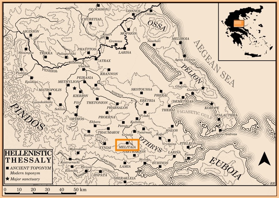
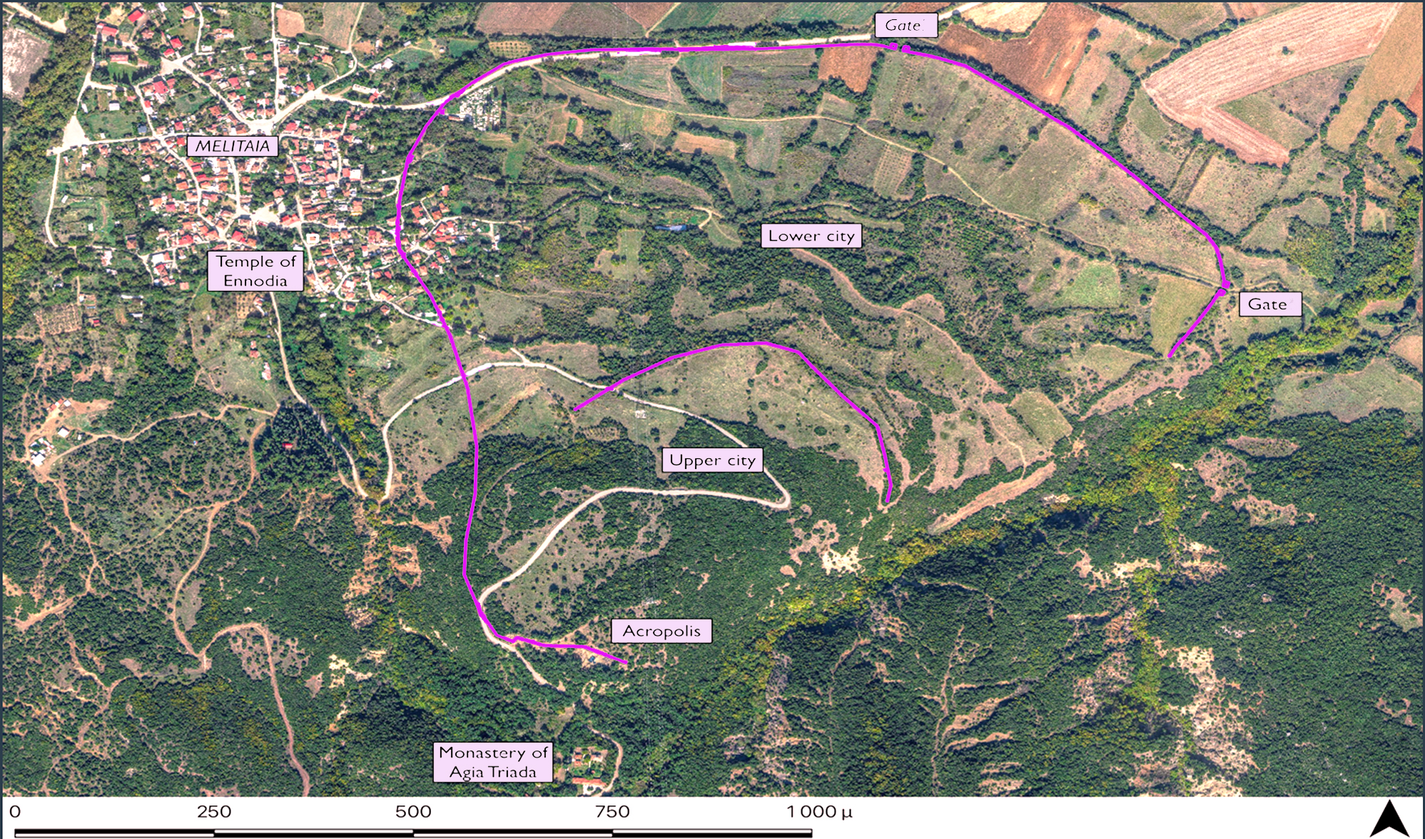
Melitaia is located in the region of Achaia Fthiotida at an altitude of 668 m. on mount Orthys. The surrounding landscape is characterized by the combination of mountainous areas, fertile cultivable Domokos plateau and the shallow Lake Xyniada (drained in 1930 and -40s) to the NW of the ancient city in the caldera of the mountain. The ancient city of Melitaia was situated on the on northern foot of the mount Orthys near the mythically important river Enipeus and east of the modern village with the same name. According to Strabo (9.5.6) the Melitaians claim that [the city of] Hellas was about ten stadia from themselves on the other side of the Enipeus, at the time when their own city was named Pyrrha, and that it was from Hellas that the Hellenes migrated to their own city; and to this they bear witness the tomb of Hellen, son of Deucalion and Pyrrha in their marketplace. Due to its strategic position, Melitaia controlled the road connecting Thessaly with the Gulf of Malia, Thermopylae and southern Greece, the central passage between Thessaly and Northern Greece. This made Melitaia a dominant city in the area of the Domokos plateau and of western Achaia Phthiotis. The city flourished from the 5th century BCE until the late Roman era. In the years of Caracalla (beginning of the 3rd century CE), the city seems to have had the epithet Sebaste (revered), a title reserved to a few important cities (such as Larissa, Lamia and Hypate), a sign of the importance that these cities had acquired at this time.
Melitaia figures in several ancient written sources, Thucydides (4.78.1,3 and 5), Plutarch (Sul. 20.1) and Strabo (9.5.6) mentioning it amongst others, and we have a number of long inscriptions indicating the arrangements in the Melitaian polis (e.g. IG IX 2, 205 from 145 BCE). The chora of the polis seems to have occupied a fairly large area, the boundaries of which are known somewhat accurately thanks to these texts. From the 4th century BC, the Melitaians participated actively in the Delphic Amphictyony, sending one of the two hieromnemones representing Achaia Phthiotis.
In the same century, the city issued bronze coins with Zeus on the obverse and a bee on the reverse. During the Lamian War, the allied forces transferred their equipment to the well-fortified city of Melitaia, while in the middle of the 3rd century BC, it joined the League of the Aetolians. In the 3rd century BCE Melitaia entered into a sympoliteia with the small neighbouring polis of Pereia (Polyb. 5.97.5f; 9.18.5-9). In 217 BCE, Philip V failed to capture the city by surprise due to the height of its walls.

Topography
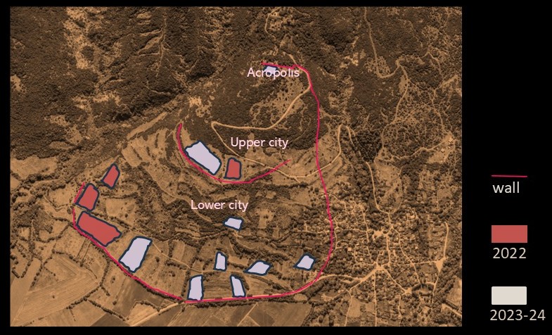
The ancient city is stacked on three large natural plateaus, that of the akropolis, of the anopolis (upper city), and the katopolis (lower city). The urban area is delimited in both east and west by the ravines of two streams. The total walled area covers approximately 67 hectares. Most of the katopolis is cultivated with cereals and fruit trees, with some areas left uncultivated. The city was strongly fortified by walls 3.80 m thick, with a dividing inner cross wall forming an upper and lower district. The akropolis has a large glade or clearing at the centre, while some parts are covered with kermes oak. Access to all sections is easy on foot along paths and dirt tracks, while the upper and lower city can also be reached by car.
Previous Archaeological Fieldwork at Melitaia
The first archaeological research carried out in the area was instigated by Nikolaos Giannopoulos in the beginning of the 20th century. Giannopoulos was the secretary of the antiquarian society Othrys in Almyros, and he recorded and collected antiquities from all over the region which were later stored to the Almyros Museum. The first more systematic research was carried out by the German Friedrich Stählin, who published an outline of the topography of the area and the first plan of the fortification of the city in 1924, in Das hellenische Thessalien (Stuttgart). In the middle of the same century, G. Bakalakis identified a substantial Middle Helladic settlement at the location Taxiarchis west of the ancient city walls. In 1971–1972 the 9th Region of Antiquities of Thebes conducted excavations on the akropolis of the ancient city, where important finds were found. Some of them are exhibited in the Archaeological Museum of Lamia.
In the 1990s, the Ephorate of Antiquities of Phthiotis and Eurytania conducted rescue excavations in the plots and fields surrounding the city walls. Many structures were found, including parts of Hellenistic houses, further tombs, a Roman villa, as well as a sanctuary of Ennodia, one of only three excavated in Thessaly and Greece. In the same decade, the Italian Floriana Cantarelli, in collaboration with the Polytechnic of Milan, carried out an extensive surface survey (non-systematic site identification) in the wider area of the plateau of Domokos and Melitaia (only partially published). From time to time, residents of the village of Melitaia have found and handed over ancient artefacts to the Ephorate in Lamia. These include tombstones, pieces of marble statuature, inscriptions, coins, metal objects, shells and figurines, indicating a time-span from the Neolithic to the Late Roman and Early Byzantine periods.
First Years
During the first field-seasons of the programme in Melitaia the following investigations have been carried out:
1. Surveys
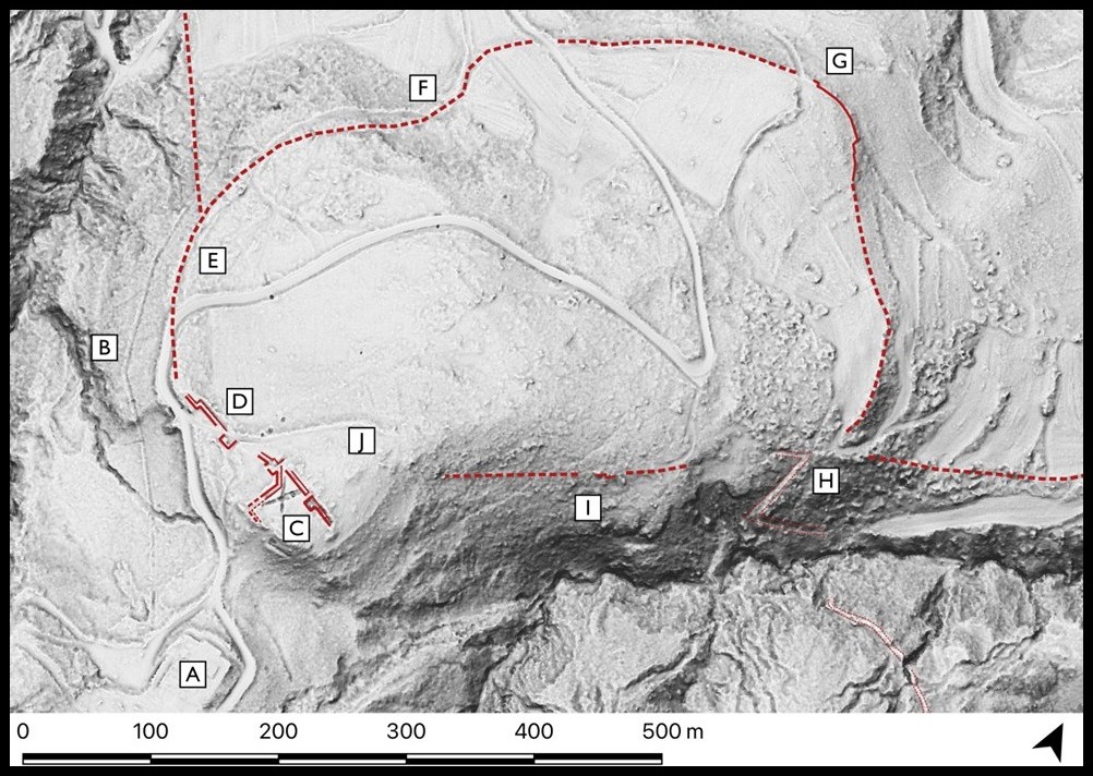
A general survey of the huge site (ca. 70 hectars) by LIDAR (Light Detection and Ranging) -investigation was carried out during the first field season. The result is an accurate relief depicting the earth’s surface, which gives indications of underground structures and helped us proceed and plan further surveys and excavation localities. Geophysical prospection has been carried out every field-season in the lower and upper city areas where GPR (Ground penetrating Radar) has been utilised, and in the acropolis area where ERT (Electrical Resistivity Tomography) has been employed. Magnetometry is well-suited for the local geology at the site. The results strongly indicate buried remains at several locations and give clear indications or roads and city-walls, foundations and rectangular shapes that could be point to buried ruins, edifices and vestiges. Survey results also indicate a potential grid (street) plan at least in the lower city area. Professor Grigoris Tsokas and his team from the University of Thessaloniki has carried out the geophysical surveys for the project; during the next years of the programme they will work also on the hybridisation model which correlates all the existing survey data.
2. Excavation
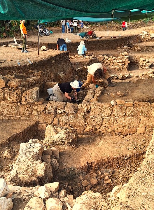
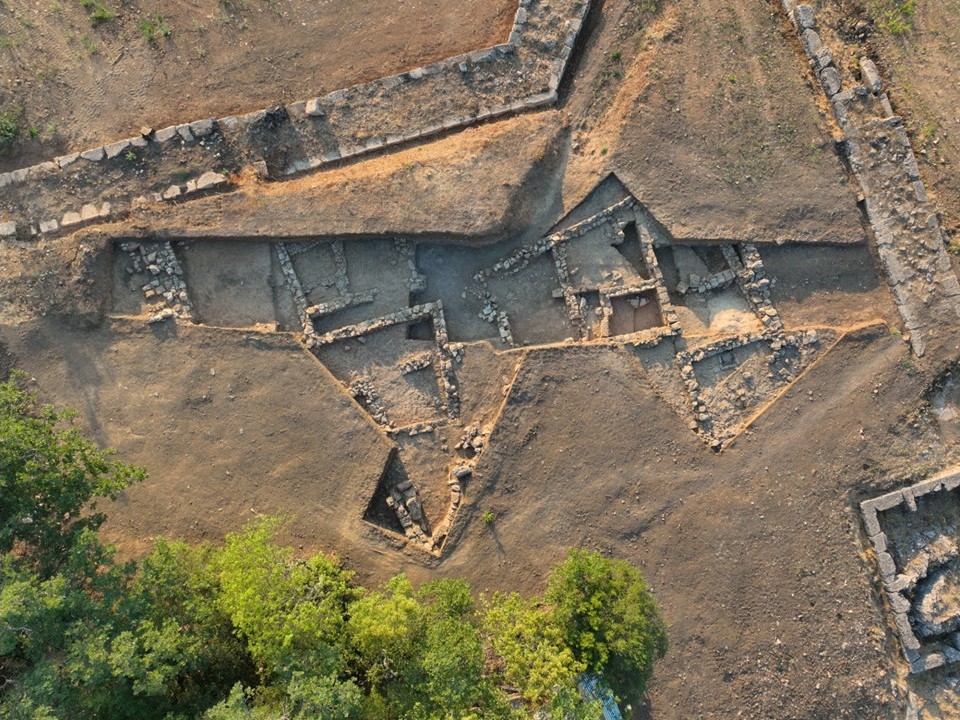
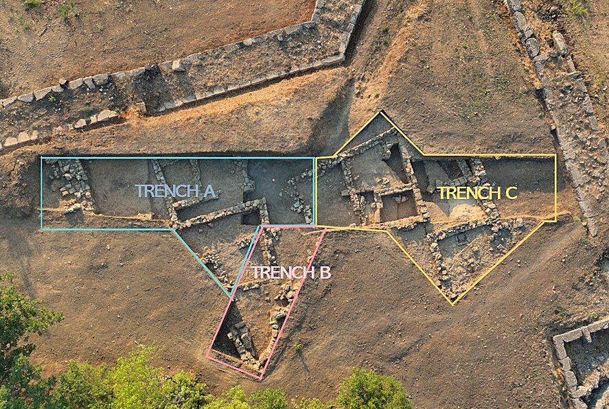
Clearing in the X-shaped trenches of the 1970’s excavations on the acropolis was the first task during the initial two field-seasons. Trenches A, B and C (Fig. below) were opened on the Acropolis for the systematic, stratified excavations. In the area, parts of two building complexes with individual structures have so far been exposed and documented. Their rather well-built limestone walls demonstrate at least five different building phases in the stratigraphy. The excavations have unearthed objects from all main find categories; lots of generally well-preserved diagnostic pottery from various periods, mostly from Hellenistic and Roman, together with metal objects and tiles, coins, bones and class fragments provide a wealth of material and interpretive challenges.
Generally, finds point to different types of past activities from various periods of time. For example, over 60 of loom weights, moulds for terracotta discs, plaques and vessel decoration point to manufacture, while fishing hooks and led weights to fishing probably in the Lake Xyniada, metal objects indicate activities relating to healing practices (bronze medical instruments), numerous large stamped and decorated tiles and metal utensils (nails, hinges etc.) to investments in construction. Coins, both local, regional (Thessalian) and Roman demonstrate contacts and mobility of people and goods, while large amounts of cooking ware, ceramic beehives and numerous lamps with various origin inform us about daily life and maintenance. An interesting foundation deposit consisting of jawbones of four piglets together with a horn of a larger animal can be read as an indication of ritual activities, jewellery and bronze fibulae and a significant number of perfume containers of local luxuries or their production. The past seems to have been respected in ancient Melitaia: much earlier, well-made items of value such as Early Archaic bronze pendants and parts of finely decorated Archaic tiles have been discovered in Hellenistic contexts.
3. Bio- and zooarchaeology
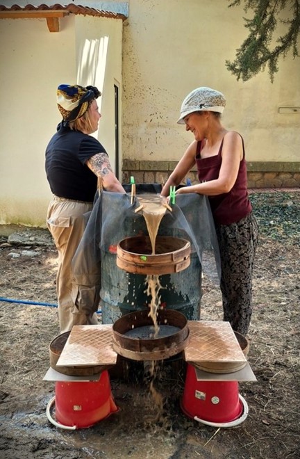
Questions pertaining to natural and anthropogenic paleogeography of Melita have been one of the main interests in the programme from its beginning. The existence and exploitation of natural resources in Melitaia and its surrounding region, changes in them and potential effects they had in the life in Melitaia are investigated using paleogeographical as well as of bio- and zooarchaeological methods. Soil samples have been water-floated from the first field-season onwards, and macrobotanical and -zoological remains are analysed in the Wiener Laboratory for Archaeological Science (ASCS).
4. Epigraphy
New epigraphical material has turned out from lower city area during the programme. Publication work of all new inscriptions is carried out by a group of epigraphists co-ordinated by Dr. Robin Rönnlund. In addition to their work on the text, they produce also 3-D models of the inscriptions using the so-called structure from motion -modelling from photogrammetric scanning.
5. Conservation
Conservation is carried out by Eva Apostolakopoulou in the work premises, arranged for the programme by the Cultural Association of Melitaia in the former school of the village, and in the Museum of Lamia for the work needing laboratory conditions.
6. Archaeo-historical study
Robin Rönnlund studied the Lidar-results (see above) by comparing them with the German scholar and epigraphist Habbo Gerhard Lolling’s remarkably detailed plan of the site in his sketches and notes depicting the visible architectural remains he observed when he visited the place in 1882. This study provides a rare glimpse of the state of the archaeological site both in the present and in the years immediately after the incorporation of Thessaly into the Kingdom of Greece. Rönnlund’s study Habbo G. Lolling at Melitaia: The Antiquities of an Ancient City through the Lens of Two 1882 Notebooks was published in Finnish Institute’s electronic publication series Grifos as volume 3; it is available here.
7. Community outreach
In the programme the community outreach is regarded as an integral part of our endeavours. Our yearly presentations of the previous results from the previous field-season in Domokos have been delightfully attended by yearly increasing number of local people. In addition to archaeological reporting, lectures by the specialist on geophysical surveying, bio- and environmental approaches in archaeology, methods of conservation and stratigraphy in archaeological work have been included into the programme. Every year the Finnish Institute has set up an exhibition at the Domokos Cultural Centre to be seen and visited at the presentation event. Bio- and environmental activities for the local school children are offered by the members of our scholarly team from 2025 onwards.

Fieldwork Teams
2025
Petra Pakkanen (FIA)
Konstantina Psarogianni (Ephorate of Antiquities of Phthiotida and Evrytania)
Lambros Stavrogiannis
Sara Eriksson
Eva Apostolakopoulou
Memi Gourdouba
Therese Emanuelsson-Paulson
Lina Enevång-Viklund
Liisa Jalkanen
Janne Kurvi
Caroline Lunt
Monica Nilsson
Andrea Nyholm
Maria Papaschou
Arto Penttinen
Tommi Raevuori
Iida-Lotta Salander
Julia Schmidt
Grigoris Tsokas
Giannis Zaharis
2024
Petra Pakkanen (FIA)
Konstantina Psarogianni (Ephorate of Antiquities of Phthiotida and Evrytania)
Lambros Stavrogiannis
Eva Apostolakopoulou
Memi Gourdouba
Therese Emanuelsson-Paulson
Lina Enevång-Viklund
Sara Eriksson
Janne Kurvi
Monica Nilsson
Andrea Nyholm
Jari Pakkanen
Maria Papaschou
Arto Penttinen
Iida-Lotta Salander
Julia Schmidt
Xenia Stavrianou
Grigoris Tsokas
Giannis Zaharis
2022
Petra Pakkanen (FIA)
Konstantina Psarogianni (Ephorate of Antiquities of Phthiotida and Evrytania)
Lambros Stavrogiannis
Juuli Ahola
Memi Gourdouba
Therese Emanuelsson-Paulson
Sara Eriksson
Tuuli Kasso
Arto Penttinen
Derek Pittman
Robin Rönnlund
Bibliography
Canlas, Gino Ruggiero L. 2021, Sacred Space and Community Identities: Sanctuaries in Broader Thessaly from the Archaic to the Early Imperial Periods. PhD Dissertation, University of Alberta: Department of History and Classics, esp. 187–191.
Hansen, Mogens H. and Nielsen, Thomas H. 2004, ‘Thessaly and Adjacent Regions’ in An inventory of archaic and classical poleis, Oxford: Oxford University Press, 715–716.
Ioannidou, Α. 1972, ’Δοκιμαστική ανασκαφή εις Μελιταίαν Φθιώτιδος’, Αρχαιολογικά Ανάλεκτα εξ Αθηνών 5 (1972), 47–55.
Rönnlund, R. 2024, Habbo G. Lolling at Melitaia: The Antiquities of an Ancient City through the Lens of Two 1882 Notebooks, Grifos vol. 3, Helsinki.
Stavrogiannis, L. 2015, ’Το ”άστυ” και η ”χώρα” της αρχαίας Μελιταίας’ in Maria-Photini Papakonstantinou & Grigorios Tziallas (επ.), ΑΣΠΑΛΙΣ Ι: Πρακτικά ημερίδας για την ιστορία και την αρχαιολογία της Μελιταίας και της ευρύτερης περιοχής της, Αθήνα 2015, 87–109.
Stavrogiannis, L. 2018, ’Οι αρχαιολογικές έρευνες στην ακρόπολη της αρχαίας Μελιταίας’, Αχαιοφθιωτικά Ε΄: Πρακτικά του Ε΄ Συνεδρίου Αλμυριωτικών Σπουδών: Ιστορία, Αρχαιολογία, Λαογραφία Αχαΐας Φθιώτιδας, 14-16 Οκτωβρίου 2016 (Α΄ τόμος), 359–375.
Mentions in ancient texts are listed on the TOPOS Texts website
Presentations
Petra Pakkanen: ’How to plan a new archaeological project and implement environmental archaeology? A case of Melitaia in Greece’, Περιβάλλον, Αρχαιολογία και Τέχνη: Γεωαρχαιολογικές και Βιοαρχαιολογικές προσεγγίσεις, Athens 14 October 2022.
Petra Pakkanen, Konstantina Psarogianni, Lambros Stavrogiannis, Robin Rönnlund and Arto Penttinen: ’The Archaeological project of Melitaia’, about the project and the finds and methods of the first season, Domokos, 18 November 2022; Program
Petra Pakkanen: ’Activities of the Finnish Institute at Athens 2022’, presentation of the fieldwork done at Melitaia during 2022, Athens, 17 May 2023
Lambros Stavrogiannis and Efthimia Karantzali: Preliminary resentation of the field season 2023 results and research methods, Melitaia, 24 August 2023.
Petra Pakkanen: ’Activities of the Finnish Institute at Athens 2022’, presentation of the fieldwork at Melitaia during 2023, Athens, 17 May 2024.
Arto Penttinen, Lambros Stavrogiannis, Eva Apostolakopoulou, Grigoris Tsokas, Robin Rönnlund: Presentation of the MELAP Field Season 2023: finds, methods and conservation, Domokos, 18 November 2023; Program
Petra Pakkanen, Sara Eriksson, Lambros Stavrogiannis: Presentation of the MELAP programme, its results, finds and the site for the group of the Support Delegation of the Finnish Institute at Athens, Melitaia, 9 October 2024.
Petra Pakkanen, Konstantina Psarogianni, Lambros Stavrogiannis: ’Αρχαία Μελιταία Δομοκου: Οι αρχαιολόγοι Πέτρα Πακάνεν, Κωνσταντίνα Ψαρογιάννη, Λάμπρος Σταυρογιάννης αποκαλύπτουν’, Radio interview on the Melitaia Archaeological Programme, Radio Lamia Polis 31 January 2025.
Evi Margariti & Maria Papaspachou, Katherina Papanikolaou, Robin Rönnlund, Lambros Stavrogiannis: Presentation of the MELAP Field Season 2024: finds, methods and conservation, Domokos, 1 February 2025.
Lambros Stavrogiannis, Petra Pakkanen, Konstantina Psarogianni: ’Αρχαιολογικό Πρόγραμμα Μελιταίας (MELAP) 2022-2024. Τα προκαταρκτικά αποτελέσματα των εργασιών στην ακρόπολη της αρχαίας Μελιταίας’ at the conference Το Αρχαιολογικό Έργο Θεσσαλίας και Στερεάς Ελλάδας 2022/2024, Volos 5 April 2025.
Media
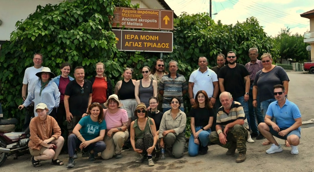
View of the site of ancient Melitaia 2022:
Presentation of the project to the Ambassador of Finland:
’The Archaeological project of Melitaia’, Presentations, 2022:
’The Archaeological Project of Melitaia’, Greetings, 2023:
Radio interview on the Melitaia Archaeological Programme, Radio Lamia Polis 31 January 2025:
Fonografos: Θ. Χειμάρας από Δομοκό: “Να αναδείξουμε τον μοναδικό πλούτο μας”, 18.11.2022
TVStar: Οικονόμου από το Δομοκό: «Το ερευνητικό πρόγραμμα θα αναδείξει το συγκριτικό πλεονέκτημα του τόπου», 19.11.2022
MAG24: Ξανά άρχισαν οι ανασκαφές του Φινλανδικού Ινστιτούτου στην αρχαία Μελιταία!, 1.7.2023
MAG24: Πλούσια τα ευρήματα και φέτος στην Αρχαία Μελιταία! Παρακολουθήσαμε την Ημερίδα (ΒΙΝΤΕΟ), 19.11.2023
